CANADA Coast to Coast – by John Baillie.
Part 2
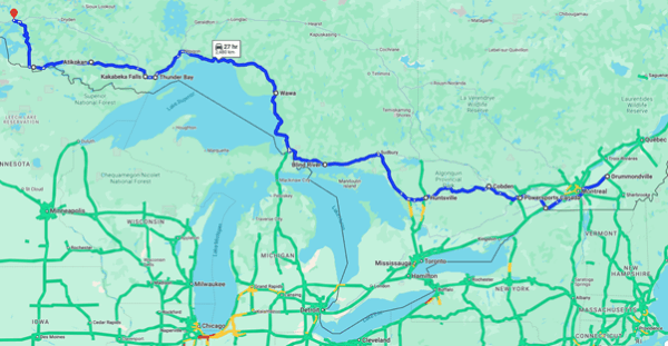
Crossing Ontario – Drummondville to Kenora
Ontario
Now following the northern bank of the St Lawrence, I crossed over into Ontario and rode ON-401 southwest until Cornwall and a very welcome pit stop! (It is possible to be overhydrated!) 6.5km north on ON-138 lies St Andrews West, the resting place of the explorer Simon Fraser, whose tracks I had crossed on my previous ride in BC. The ride up to Ottawa was pleasant enough in gently rolling countryside, along the very straight ON-138 until it reached ON-417 and then it was a highway ride to Power Sports Canada.
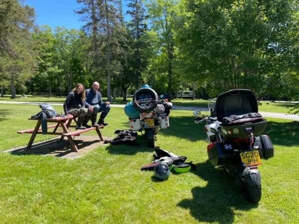
On the ramp at Powersports in Ottawa
They had the bike on the ramps right away and diagnosed a fault with an exhaust valve sensor fault. The diagnostics confirmed that the fault had registered about 160km west of St John’s. I was asked if I had I been down on power. I had felt the bike a bit sluggish but had put it down to the weight of the luggage. The good news was that riding on had not damaged the engine. More good news was that they had a sensor in stock and could fit it right away. Off I went to get something to eat while they worked on the bike.
It transpired that the sensor was fine. The wires to the sensor had been cut by the fan as a result of poor routing when the bike was worked on before I set off. The technician mended the wiring. Not only that but he also cleaned the chain and lubed it and adjusted the suspension for the load I had. I had been expecting that it was just a fault code that needed to be cleared. It was excellent service from friendly people.
Somewhat relieved, I set off again in the late afternoon for Cobden, on Muskrat Lake. Cobden hadn’t been on the original route. This day was supposed to have been Mont-Tremblant to Kingston, via Thousand Islands, to allow me to ride the Ontario Highlands. One of the Canadians (thanks Fred) who helped me retune my route to catch up time had suggested that I could cut out this leg. Another friend, Norman, had introduced me to his family in Cobden, Ontario and when I rerouted through Ontario, I saw that I would pass by them, so Cobden became part of the plan.
The ride up from Ottawa was fairly easy. A little busy but nowhere near as bad as riding in Friday afternoon Ottawa traffic on Canada Day weekend could have been. Around Glasgow Station, the ON-417 becomes ON-17 and changes from dual carriageway to two lane highway but it’s still TCH. About 10 miles west of Glasgow Station is Renfrew and in Renfrew County was the turn off for Lochwhinnoch. All names from my childhood and all close together. There must have been a shipload came here at one time.
After a short detour to the LCBO to pick up a bottle, I found the Woodfines at their beautiful spot on the shore of Muskrat Lake. Norman’s nephew Stephen and his family made me very welcome with great company, a beautiful meal, a peaceful place to spend the night, a garage for the bike and clean clothes for the next day. Thank you all very much.
Cobden to Huntsville – 241km, 18, 29th June
Wet bike, wet biker, Madawaska ON
A short day but one to take in part of the Ontario Highlands and ride through Algonquin Park. The weather apps said probably no rain, the sky said maybe, so I set off with the waterproofs packed away, my last words that I wouldn’t need them today or they will be on in 10 minutes. They were on in 10 minutes and stayed on all day. Despite the rain, the ride on ON-60 was good. It would have been a scream in the dry, but it was quiet and the scenery was beautiful with forest and lakes. The rain (and mosquitos) meant it wasn’t a day for stops, with only a couple of pauses for photos and food. I arrived in Huntsville early afternoon by which time the rain went off!
Huntsville to Blind River – 409km, 6 & 29, 30th June
It was a day of two halves! At 6am I made the usual checks. The weather channel showed no rain, the apps showed no rain, and the rainfall radar showed no rain, the sky was grey but bright. At 7:30 I was on the bike with the waterproofs packed away and as I pull out of the motel parking and crested the hill all I could see was what looked like rain clouds, so I pulled over and checked the apps again. Still nothing showing. Huntsville is at 1000ft, so I guessed it was just low cloud. It was warm enough so I rode on thinking I wouldn’t get too wet if it was just low cloud.
Cold and wet, coffee and petrol at Magnetawan ON
I had been really looking forward to riding ON-141. It was damp and I could see it was a great biking road but as I rode on, it became too wet for heroic cornering, and I was getting damp. By the time I reached ON-400 and turned north, the rain really started. Stopping at the roadside was still an issue. There is generally no tarmac beyond the white line, just gravel sloping steeply off into the drainage ditch. Nowhere for a bike to be! There were very few laybys but right when I needed somewhere, a truck inspection point appeared, so I pulled over and put waterproofs over my wet clothes. The temperature had dropped from 16 to 6 and it was miserable. After 75km of heavy rain on ON-69, it had eased off and it was time for coffee. It was still only 12.
After a fill of petrol at the Magnetawan Reservation Esso it was time for a coffee at Tim Horton’s. I was bought another coffee by people who wanted to talk about where I was from and about the ride. This had happened quite a bit during the ride and as usual, it cheered me up. The waterproofs were dry enough to stow away and I thought the rest of my gear could do with a chance to dry while riding. Further north, towards Sudbury, things became less cold and the scenery changed with the trees thinning out and the lakes joined instead by rocky outcrops. By the time I turned west again on ON-17, it was time for lunch but there was nothing for another 50km until I reached Nairn Centre, 280km in on the day. This is where I met a guy in jeans and a shirt who had ridden up from New York on a knackered old bike he’d had just bought!
Just when I needed it, a chance meeting with Kev and Lexi on the way to Blind River
It was now in the high 20s. As part of my preparation, I had learned the importance of keeping hydrated and fed. Earlier in the ride I had worked out just how much water I had to drink to stay hydrated, to stay awake. With the weather today, I had neither drunk enough nor had I eaten often enough and by the time I reached Serpent River, only 80km on from my “lunch” stop and only 30km from my destination, I was really struggling. Just when I needed it, there was a sign for a rest stop. I pulled in next to another bike and saw a UK registration plate on the back. Lexi and Kev, from Cornwall, were on their way from Calgary to Ushuaia. That’s an adventure! We exchanged stories while I drank all my water and ate my emergency rations and when I set off again, it was fully refreshed and alert and with a smile on my face. Much safer!
On the shores of Lake Huron, Blind River ON
I arrived at the motel to a temperature of 29. There was enough time for some sightseeing, so I headed down to the beach and my first sight of the Great Lakes, Lake Huron. It was beautiful. Back to the motel in good spirits to freshen up. The owner of the motel had given me a couple of recommendations for places to eat in Blind River but on the way back from the beach, I had noticed that they were all shut. It was Sunday and not just that but Sunday on Canada Day weekend. The owner of the motel phoned around and confirmed that Pier Seventeen at the other end of town was open and it was excellent. The walk also gave me the time to call Ions in Baltimore for catch up. On the way back to the motel, walking along the TCH, it was very peaceful, there was no traffic. Canada Day weekend Sunday evening.
Back at the motel, my neighbour was a fellow biker on his monthly commute from New Brunswick to the Alberta gold mines so we exchanged stories before I turned in, exhausted.
Blind River to Wawa – 375km, 21, 1st July Canada Day
I woke to a beautiful, cool, sunny day and took a leisurely start to the day (8am on the road). I was beginning to believe that I would catch up the lost time and with the big cities far behind, I really started to relax into the ride.
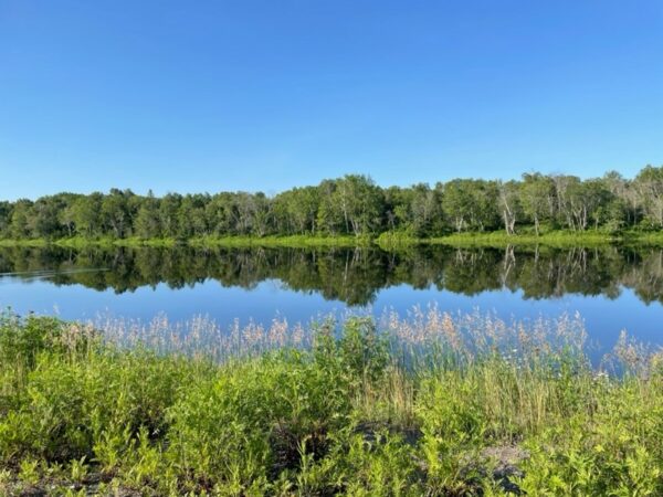
Early morning ride along the Blind River heading west to Sault Ste Marie
The stretch along the Blind River was breathtaking. With no wind, the reflections of the sky and trees on the water went on for mile after mile. After an hour or so, I stopped for breakfast at Bruce Mines on the shores of Lake Huron. Bobbers Restaurant was one of many lucky finds I made along the way. Friendly and welcoming for a top-notch breakfast. The views across the lakeside outstanding at Bruce Mines.
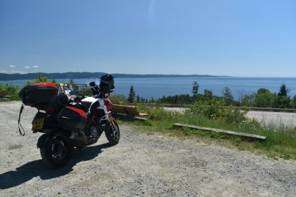
By late morning, ON-17 had carried me west to Sault Ste Marie, straddling the border between the US and Canada and where Lake Superior cascades into Lake Huron. I took a detour to the waterfront for some photos of America and to fill up before heading “north of The Soo” along the eastern shores of Lake Superior. The ride along Lake Superior was outstanding, sweeping curves with a well-made surface, spectacular views of the lake alternating with tall forest trees but from time to time, it was the same as parts of QC-132 along the St Lawrence. It seemed like the roadbuilders just plough through a hill to keep the road flat and straight instead of adding curves. Still, there were enough curves to keep a smile on my face. There were lots of places to stop and take in the view and with relatively few kilometres to ride in the day, I stopped when I wanted.
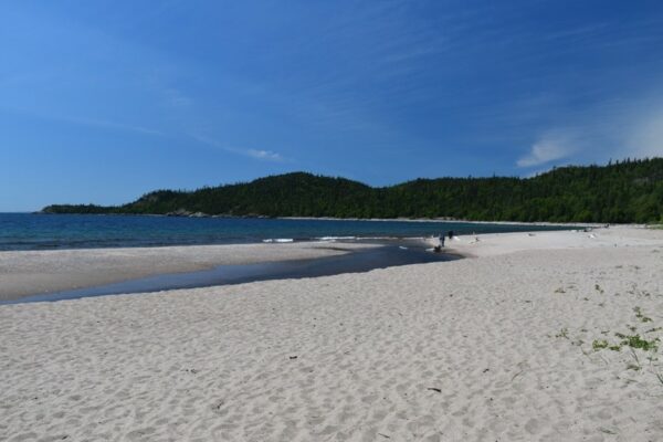
Lake Superior – sandy beaches 1
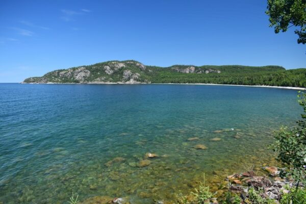
Clear waters
and panoramic views!
 I arrived at the Outdoorsman Motel feeling great and to a biker friendly welcome.
In a repeat of Blind River, the owner of the motel made a few calls and found somewhere for me to eat, at the other end of the town and again, I enjoyed the walk. Everyone I had met since picking up the bike had been so friendly and helpful. It made everything better. The motel soon filled up with bikers, most of whom knew the routine, bring your own provisions and use the barbeques provided. Some American Harlistas and I would be heading for the other end of town. I arrived first. At one time, the Lakeview Hotel must have been rather grand, but I don’t suppose the TCH bypassing the town helped their profits. As it was, it was open, it had food and beer, and it was full of bikers. Some travelling east, some west, some north and some south. We all sat in the sun and exchanged stories. It was lovely.
Wawa to Thunder Bay – 484km, 13, 2nd July
I had been invited to ride with company to Thunder Bay, but I woke early and although the sky was blue, it was cold, and the weather apps promised rain later in the day. I decided to leave early and get as much of the long day under my belt in the dry.
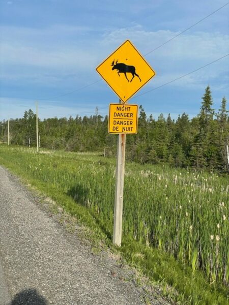
This sign kept me smiling, threat or promise?
The first part of the ride heads north, away from the lake before heading west again to find the lake at Marathon. Most of the way is a mixture of trees and lakes and bare rock. Even though Wawa is further south than Paris, there was a real sense of being in the northern latitudes with long stretches of isolation!
By Marathon, the sky was beginning to look threatening. It was time to stop for breakfast. I spoke to some bikers who had come from Thunder Bay in the dry, so I filled up hoping to beat the rain to Thunder Bay. I left my waterproofs in the panniers and headed off to fill up the bike and as I left the petrol station, the first spits of rain came. I had 300km still to cover, the rain was forecast to come in off the lake and I didn’t want to repeat the mistake of two days before so on went the waterproofs. They stayed on until Thunder Bay! The road from Marathon to Nipigon looks like it would be fantastic in the dry. This day, the rain just got heavier and heavier until I was reduced to 40kph with my hazard indicators flashing, barely able to see through my misted-up glasses and with rain running up and down my screen and visor. Lorries were thundering past kicking up spray and I was riding through either mist or low cloud. It was awful! Then the roadworks started and added mud, traffic lights and contraflow to the equation. Somewhere short of Thunder Bay the rain eased off and stopped and my waterproofs were just about dry by the time I rolled up at the hotel having ridden almost 500km by 1pm. There just was no attraction in stopping in such vile conditions. I didn’t know it at the time but that was the last rain I would see in Canada.
After drying out, warming up and getting some laundry done, I headed out to explore Thunder Bay, first stop at Maletta’s barber shop to get my beard under control, then a walk along the waterfront before finding some food and drink. Later in the Lakehead Brewery quiz night, in a team of three made up when the quizmaster put me with two others, we managed to claw back from last and second last to third and a prize, a free beer which I could collect next night.
Happy and tired, and knowing I wouldn’t be riding the next day, I crawled into bed and slept soundly.
Thunder Bay to Thunder Bay – 75km, 25, 3rd July
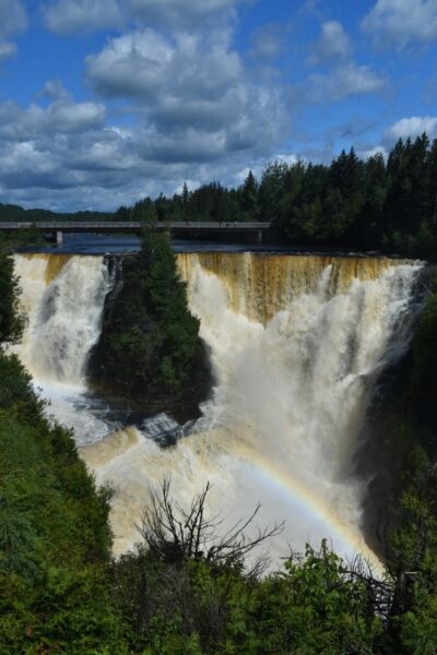
Kakabeka Falls
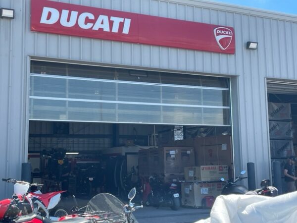
Back in Wawa, an ambassador of the North American BMW owners club had given me the name of Brown Street Bike Shop in Thunder Bay. They had needed a tyre fitted on a Sunday and the owner had opened up the shop especially to change the tyre for them. I needed to clean and lube my chain after all the rain and road dirt so off I headed down to Fort William. I found the bike shop down beside the grain silos and railway yards. I was quickly ushered round to the workshop entrance to bring the bike in out the hot sun to work on and given a tin of chain lube to help myself. Typical Canadian hospitality with friendly biker bonus! After a tour of the workshop, dyno and storage it felt only right to buy a t-shirt from them.
Travelling alone means talking to people and that means getting local tips for places to visit. The previous evening, I had been told about Kakabeka Falls, just west of town. “Canada’s Niagara Falls”, I thought Canada already had a Niagara Falls but headed off anyway. Walking around in bike gear in the sun was very hot but the falls were well worth it, especially in the refreshing spray from the falls. Back in Thunder Bay, I explored the waterfront, rested and relaxed. I had been warned that there wasn’t much west of Cobden when I was there, and I don’t imagine Thunder Bay was much about twenty or even ten years ago but there has been money spent on it recently and parts are on the up. There are a couple of places to eat and drink but fentanyl never seems far away in Canada.
I redeemed my third prize from the quiz for a beer at the Lakehead Beer Company and strolled back to the hotel. Packed, as usual, for the next day to be on the move for a long day.
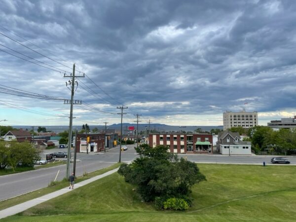
Thunder Bay ON, big skies, last rain of the trip
Thunder Bay to Kenora – 560km, 29, 4th July
There was a choice of routes to get to Kenora. Carry on on the busier main TCH ON-17 (479km) or cut off at Shabaqua Corners and take the quieter ON-11 via Fort Frances, adding 80km. I took the quieter road. Thunder Bay to Fort Frances is about 338km. I might just make it on one tank, but I had been being cautious, filling at about half full, so I didn’t have any confidence for my exact range. I decided to fill up on the outskirts of Thunder Bay, but the satnav took me to a derelict petrol station, then another and then none until Fort Frances! Google assured me there was petrol in Atikokan, off the highway 200km along ON-11. I pressed on.
Somewhere about 65km west of Thunder Bay, still well inside Ontario, I passed a sign advising that I was now in Central Time Zone. It was now 15 minutes before I had left in the morning. I had started at 47.6N 52.6W and was now at 48.6N and 90W, not quite an eighth of the way around the world. Half an hour later I was at the Arctic Watershed at Kashabowie where I got reassurance about the petrol station at Atikokan and warning that there were bears on the road further up. I never saw the bears!
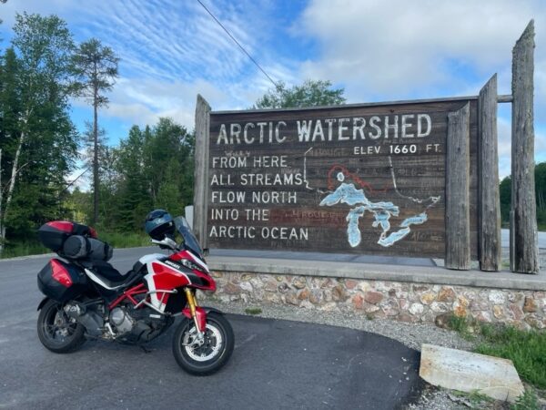
A watershed moment on ON-11!
Forty minutes later, I was scrambling around the mosquito infested, sloping, gravel forecourt of the Inver filling station trying to find somewhere level enough to park the bike and fill up. In the remote parts of Canada, the fuel storage tanks are above ground. I couldn’t work out how to pump any petrol so, still fully gloved and helmeted up against the mozzies, I made for the kiosk and learned how to unlock the pump and get it working and “make sure you remember how many dollars fuel you have put in because the pump isn’t linked to the till”. How much this was down to trust and how much to an aversion to mozzie bites I’ll never know.
By the time I reached Fort Frances, the forest with lakes had more or less given way to lakes with forest. Fort Frances is right on the border and maybe because I was trying to avoid the crossing, I missed anywhere to stop. A short time later I was in Emo and with nowhere for lunch, it was a forecourt lunch again. The big yellow number plate had opened many conversations and there was no exception here. The two people working at the petrol station each came out for a chat and the two railroad workers in their road and rail pick-up were also interested.
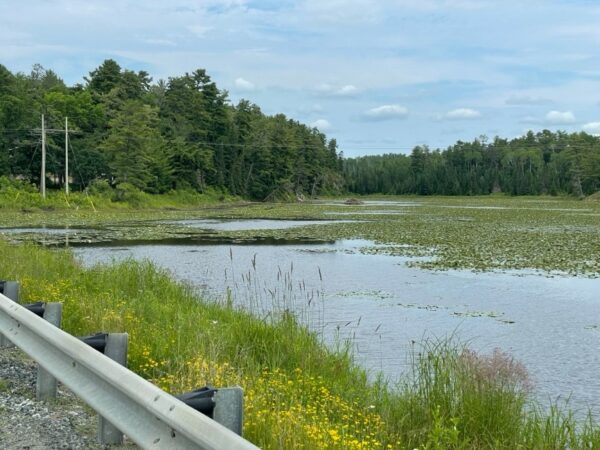
Lily pads and beaver lodges, all day long
Turning north onto ON-71 towards Kenora, the road is arrow straight, the lakes with forest give way to scrubby forest and pastureland before the forest and the lakes eventually take over control again. Kenora is on the appropriately named Lake of the Woods. All day I had been riding by lakes with lily pads and beaver lodges but there weren’t as many places to stop today as on the shores of Lake Superior. Even so, I managed stops at Morson and Sebaskong Bay to photograph a flavour of the scenery. The stretch from Emo north is wilderness and although I had eaten and drunk at Atikokan and Emo, it was a hot day, and I needed to take a break with 75km more of nothing but trees and water until Kenora. I was so hot and thirsty, and I drank a frozen lemonade too quickly and gave myself some absolutely rotten stomach cramps. Ouch! Riding on I came to the rest stop at Bunny Lake. Rest stops were so few and far between that I decided there must be good reason for this one, so I pulled in. There was a lovely lake view and a Harlista with the now customary offer of a beer. I explained why I wouldn’t take him up on his kind offer and we chatted in the shade of some pine trees. He was on his way south from Kenora and had only made it 60km before needing a beer?
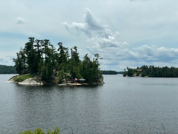
Nearing Kenora, Morson ON
On these hot afternoons, I was learning to stop when I could, and this made the run in to Kenora with beautiful lake views and lakeside houses all the more enjoyable. Even with the unexpected extra hour (I had changed time zone again just west of Thunder Bay), it was still 4pm by the time I reached Kenora after nine hours on the road.
Unpacked and freshened up, I headed out around six for a sundowner and some food. Back in Thunder Bay, Fred (my Ontario contact) had recommended Lake of the Woods beer and Kenora is the home of the brewery. The first place I came to looked great, on the lake and with a deck. The food selection looked ok, but the beer was North American yellow chemical water, I bailed out and found the brewhouse just around the corner with excellent beer and standard pub food.